| Mount Katahdin, Maine 5,267 feet |
Climbed 9/14/1992 |
Mount Katahdin was the first state highpoint that Evelyn and I climbed together. The idea of visiting them all had not even occurred to us yet.
While planning our trip to New England, I knew I wanted to get up into the north woods of Maine. But which hike to take? I ended up choosing Mount Katahdin for a few reasons:
- It was in Baxter State Park, which has many miles of undeveloped woodland to explore.
- It was the northern end of the Appalachian Trail.
- We could follow The Knife's Edge Trail, which sounded very cool.
- It was the highest point around, meaning it would provide a good view.
Truthfully, it was the description of The Knife's Edge Trail that was the deciding factor: a narrow ridge trail with a steep drop-off on both sides. The fact that it was the highest point in the state was peripheral.
We drove along the dirt roads of Baxter Park for what felt like a very long time before we arrived at the trailhead. We seemed to have the park to ourselves. The register we signed at the trailhead showed only one party ahead of us. I shouldered the REI suitcase that converted to a backpack and we set off through prototypical woods, with the nice variety of trees you find in New England. Before long, though, we reached a very steep rock pile — the base of the ridge. We knew that the trail climbed the rocks because we could see bright blue paint on some of the rocks. As far as we could tell, though, those blue trail markers were the extent of the maintained trail. It was up to us to scramble over the boulders in whatever way we saw fit. Which we did, gaining several hundred feet of elevation with very little hortizontal distance.
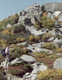
Notice the blue lines which mark the trail
From the top of this steep section (Pamola Chimney Peak) we could see the summit off to the northwest. Between us lay The Knife's Edge Trail. It was marked in the same way as the trail we had been following, and similarly involved scrambling over or around large boulders. As advertised, the ridge dropped off steeply for hundreds of feet on either side, but the trail wasn't so narrow that it felt vertiginous.
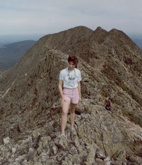
Along the Knife's Edge looking back toward Pamola Peak
We made steady progress along the ridge. It sometimes seemed slow — mountain travel always feels slower when you can see the destination — but soon enough we reached the summit. Of course it wasn't the actual summit, it never is. We had reached South Peak and we had another quarter mile to go.
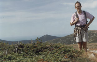
To avoid the raging winds and the crushing snow
of the mountain top, the pine trees remain very small.
When we got to the real summit, the view was clear, it was not too cold, and we sat and ate a bit of lunch. We met a few hikers who came up the other side of the mountain on the Appalachian Trail, but none who were completing the whole trek from Georgia.
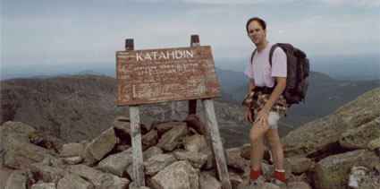
4.5 miles, 3800 ft elevation gain, 5 hrs 40 mins
We decided to descend by a different trail, one that led down to the lake we could see in the basin to the north of the mountain. From the top the trail looked smoother than the one we took up, but it turned out to be a steep talus slope running down the fold of a saddle. We had to walk carefully to avoid twisting our ankles on the loose rocks.
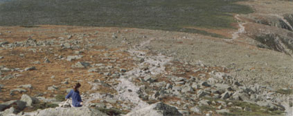
The path looks smooth, but the actuality is maddening
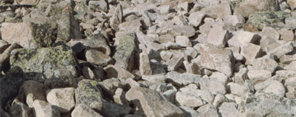
The rocks continued once we were back down in the trees. When we got to the campground at Chimney Pond we felt like we were nearly done, but we were wrong. We kept heading down and down and down, much farther it seemed than we had traveled up. The rocks gave way to dense networks of roots. Evelyn began to go mad about not being able to set her foot flatly on the ground.
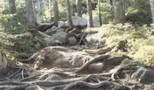
Roots cover the ground like a tangle of slippery snakes
Hours passed as we wondered how far we had left to go. Finally, about nine hours after we started, we reached the car. Exhaustedly, we drove back to the motel in Millinocket. As we stumbled to our room, Evelyn grabbed the pack from the back seat of the car and couldn't believe I had been carrying that weight all day.
We felt quite accomplished. With the memory of the interminable hike from the campground to the car faded, we remember a difficult but satisfying trip in the north woods.